
PHOTOGRAPH READING AND INTERPRETATION
Types of Photographs
Types of Photographs
Identify types of photographs
A photograph is an image or a picture of an object which is recorded by a camera and then printed on a paper. Photograph interpretation is a process of reading, measuring and interpreting photographs for obtaining reliable information about natural or human features and their environment. In other words, photograph interpretation can be defined as analysis and examination of photographs so as to be able to identify natural or artificial features.
Photographs are classified according to the viewpoint or position from which they are taken. They can be taken from the ground or from the air. This then basically gives us three major types of photographs namely, horizontal, oblique and vertical photographs.
Horizontal or ground photographs
These are photographs that are taken from the ground when the camera is at the same level as object(s) being photographed. There are two categories of horizontal photographs as described below:
Horizontal close-up photographs
These are categories of horizontal photographs in which the camera focuses on a particular object such as a house. The object of focus is shown very clearly. On the other hand, objects in the background are obscured, and generally, the background is not seen clearly.
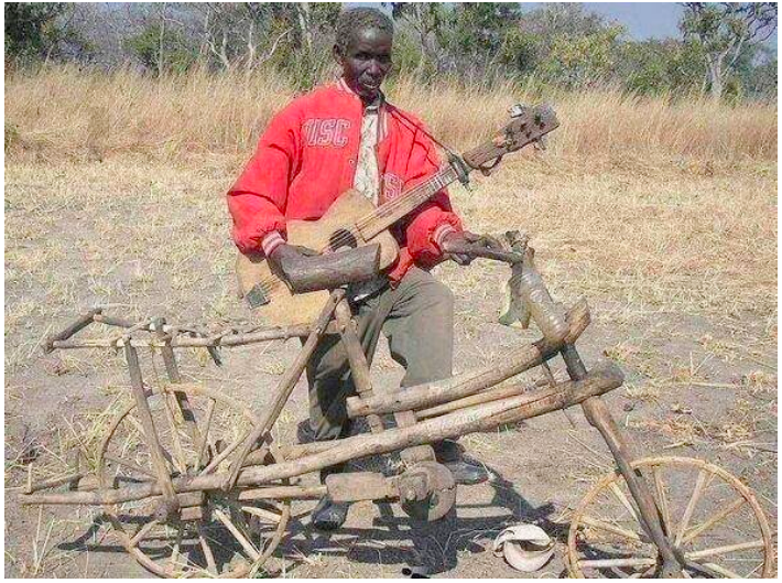
Horizontal general-view photographs
These are photographs that focus on a wide area of the field. Several objects are clearly shown in these photographs. Objects close to the camera appear larger than those far away from the camera. The area whose objects are obscured from the camera by those objects close to the camera is called the dead ground.
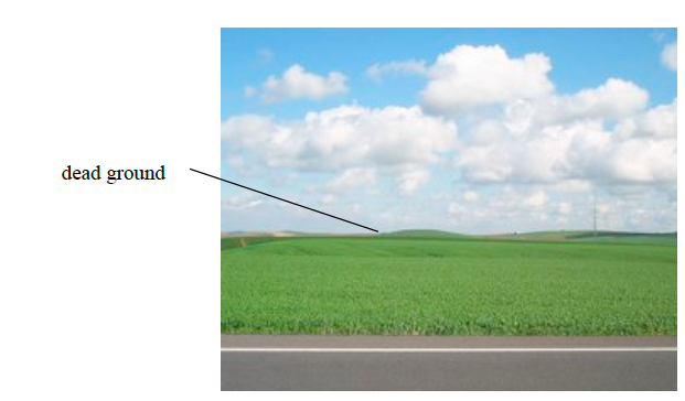
Horizontal general-view photograph
Oblique photographs
These are types of photographs that are taken from an angle, usually from the top of a hill, tower or cliff. There are two categories of oblique photographs as described below:
Ground oblique photographs
These are taken when the photographer is standing in elevated ground, such as top of a hill, building or cliff, and holds the camera at an angle pointing towards the lower ground. The photograph can also be taken when the photographer is standing at the bottom of an elevated ground, with the camera pointing towards the higher ground (See the photograph below). So, whether the photograph is taken from the top or bottom of an elevated ground, the resulting photograph is called ground oblique photograph. In this kind of photograph, the images closer to the camera are larger than those far away.
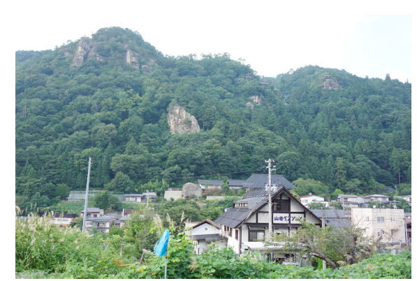
Ground oblique photograph
Aerial oblique photographs
These photographs are taken from the sky with the camera tilted at an angle towards the ground. The photographer may take the photograph from a helicopter or low-flying aeroplane. These photographs cover quite a large area of land. They are similar in many ways to the ground oblique photographs. Objects near the camera appear slightly larger than those far away.
An aerial oblique photograph which does not cover the horizon is called a low aerial oblique photograph, while that which includes the horizon is called a high aerial oblique photograph.
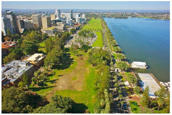
LOW aerial oblique photograph
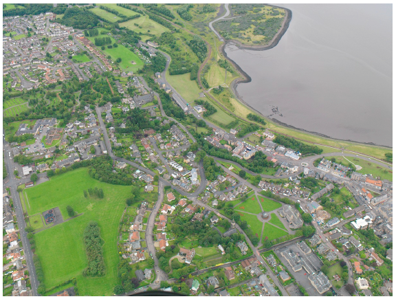
HIGH aerial oblique photograph
Vertical photographs
These photographs are the ones that are taken from the air with the camera directly above the scenery, pointing vertically to the ground. The camera focuses on specific features on the ground though the area surrounding those features is also shown.
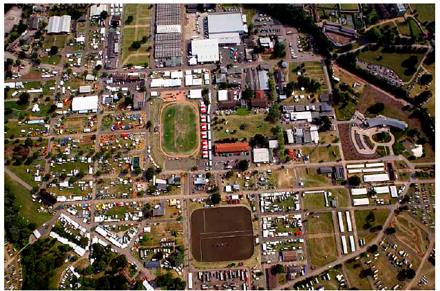
Vertical aerial photograph
Differences between Ground, Vertical and Oblique Photographs
Differentiate between ground, vertical and oblique photographs
A photograph has three parts as described below:
- Background – the area farthest from the camera.
- Foreground – the area nearest to the camera.
- Middle ground – the area between the background and the foreground, which is at middle distance from the camera.
Each of the three parts of the photograph can further be sub-divided into three parts to give nine combinations which form the nine minor parts of the photograph as shown in the table below:
| Left | Centre | Right |
| Left background | Centre background | Right background |
| Left middle ground | Centre middle ground | Right middle ground |
| Left foreground | Centre foreground | Right foreground |
For easy description of locations on a photograph, it is appropriate to use these divisions. It is inappropriate to use such terms as ‘top’ or ‘bottom’ when referring to areas or parts of a photograph. Also it is not acceptable to use points of the compass such as ‘east’, or ‘north’ unless there is sufficient information to enable one to determine the compass directions of the photograph.
Reading and Interpreting Photographs
Features Presented on Photographs
Read features presented on photographs
The same as reading maps, reading a photograph means studying and identifying the various objects shown on the photograph. Interpreting a photograph means examining the objects or a combination of objects shown on the photograph for the purpose of judging their significance. It involves translating the information by describing the features shown in the photograph. Photograph interpretation involves the following:
- Determining the title of the photograph.
- Estimating time and season the photograph was taken.
- Estimating direction or position of the photographer.
- Estimating the size of the features.
- Identifying and interpreting physical features.
- Identifying and interpreting human activities.
- Suggesting possible location of the scenery in the photograph.
Determining the title
A suitable title of the photograph can be obtained by studying the photograph carefully. The information obtained in the photograph determines the choice of the title.
Features shown on the photograph can be natural or man-made. It is important to study the photograph carefully and identify these features.
Photographs show landscapes, activities on land, water surfaces or sky or a combination of all of these. The information contained in the background, middle ground and foreground should be carefully studied. Such information, when combined with one’s geographical knowledge can be used to establish the title of the photograph.
Estimating time and season
If we know where the photograph was taken, it may be possible to tell the time of the day when the photograph was taken. If it was taken in the tropics on a sunny day, long shadows imply that the time of the day was either early morning or late afternoon. If the shadows are short, it implies that the time of the day was just before or afternoon. In the temperate regions, both in the southern and northern hemispheres, the sun never gets overhead at noon. It remains at an angle. The shadows are also shortest at noon and point northwards in the northern hemisphere and southwards in the southern hemisphere. Therefore, based on the knowledge of the zones of the earth and the movement of the sun, one can tell when the photograph was taken and be able to determine a part of the hemisphere on which it was taken.
We can also draw conclusions about weather, season or even climate of the area at the time the photograph was taken. A bright clear sky with dry vegetation may suggest a dry period or season. Thick vegetation, young crops and or flowering plants in the field and a sky full of cloud cover or rain suggest a rainy season or period. In temperate regions, clear sunny conditions with healthy vegetation and flowering plants or plants with fruits indicate a summer season. Plants with young leaves, others in bloom and fields full of grass could be an indication of spring season. Foggy sky with leafless trees and some snow on the ground is an indication of winter season.
The type of clothing worn by people appearing in the photograph and the nature of houses can be a clue to the prevailing weather or the type of climate. When people appear to be wearing heavy clothing with faces almost completely covered, hand gloves and heavy boots, it is an indication of cold weather, likely to be winter in temperate regions.
When the weather is hot, people wear light clothing and some may even wear broad-rimmed hats. If people are seen basking in the sun by the swimming pool it also indicates a warm sunny, hot weather. When houses appear to have slanting roofs, it is an indication that the region experiences a lot of precipitation, either rainfall or snow. Slanting roofs facilitate easy flow of water or snow from the roof of the house. Simple houses with flat roofs indicate a region that experience little precipitation or that is dry in most of the year.
Activities going on in the field could also suggest the type of a season. If people are seen planting crops, it is planting season. The rainy season is either near or it has just started. If people are seen weeding, it is the growing season for crops and there is reduced rainfall.
If people are photographed harvesting the crop, it is the harvesting season and is probably dry season because harvesting normally takes place during dry season with a few exceptions. The time of the year could also be indicated by a combination of phenomena in the photograph.
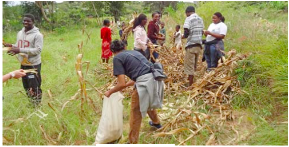
Maize harvesting
Estimating direction
This refers to identifying the position of the photographer after studying the relative sizes of objects in the photograph. It is possible to estimate the direction on a photograph using shadows. This is possible if the time and place where the photograph was taken are known. For example, if a photograph shows a tree whose shadow is on the right and it is indicated that it was taken within the tropics and in the morning, then the photographer was facing south. The sun and the shadow are always in the opposite sides of the photograph. If the sun is in the east, the shadow will always be cast westwards and vice versa. If the shadow is pointing towards you and the photograph was taken in the afternoon (meaning that the sun was in the west), the photographer was facing westwards. With such information, it is then possible to fix compass points on a photograph.
The other alternative for identifying the position of the photographer or cameraman is by observing the size of objects in the photograph. The objects close to the photographer appear larger those far away. The objects apparently appear to decrease in size as their distance from the photographer increase. Therefore, the part of the photograph showing huge objects is the place close to where the photographer stood. Study the photograph below carefully and keenly. Can you tell the position of the photographer?

Size of images gives a clue on the photographer’s position
Estimating the size of features
Due to perspective nature of photographs, especially with regard to the ground general view photographs, it is not ease to measure and calculate possible distances from them. It is, however, possible to work out approximate sizes of objects using familiar objects in the close-up photograph such as a person, ruler or coin. This gives an impression of the relative sizes of the objects and from this we can be in a position of estimating the size of a given object in a photograph.
That is why, we normally see a coin, hammer or ruler or any known object placed against rock strata to give us an idea about the size of the rock.
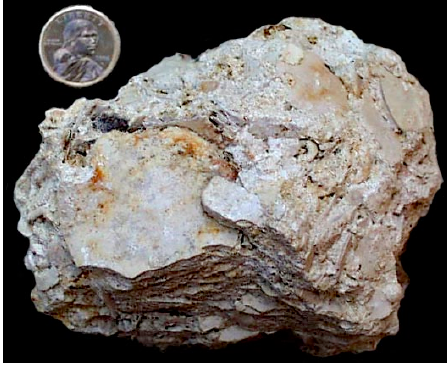
We see a person standing against a cliff or tree so that we can use that person to estimate the height of the cliff or tree. This is done by first estimating the height of the person and comparing it with the height of the object and then estimating how many times the tree is taller than the person. In this way, we can estimate the height of crops such as tea, coffee and sisal.
A ruler placed against the face of a rock can be useful in estimating the thickness of the rock layer. Since the length of the ruler is known, its actual length as it appears in the photograph can be used to estimate how many ruler lengths there are in the whole rock layer.
It is difficult to determine distances and areas accurately in photographs. This is because objects in a photograph are not of uniform size and height. Objects in the foreground always appear larger than objects of the same size in the background.
Natural and Manmade Features in the Fore, Middle and Background of the Photograph
Identify natural and manmade features in the fore, middle and background of the photograph
Many physical features shown in the photograph can be identified and interpreted. These features include relief, drainage, and vegetation, among others.
Relief
Before interpretation of other physical features, it is important to first identify relief features on the photograph. Start by giving a general idea about the area shown in the photograph. In describing landscape and landforms, it is important to go even further and describe the forces and processes that are responsible for their formation and modification. This is an essential aspect of relief interpretation. Relief features in the photograph may include the following features:
Flat landscapes
These landscapes occur both in lowland and highland areas. They are called plains in the lowlands and plateaus in the highlands. Plains altitudes are less than 500 metres while plateau altitudes are more than 500 metres above sea level.
It is impossible to tell the average area of the land directly from a photograph. However, other features appearing in the photograph, such as part of the sea, crops and other economic activities may be used in estimating the altitude. Where there is an accompanying topographical map of the area, it would then be easier to state the height of the land from the map.
Where there is no sufficient information to tell the height of the land, relief may be described as flat. One can then suggest that it is probably a low-lying plain or a plateau surface. Some flat areas may be described as flat lowlands or highlands.
Hilly areas
A hilly landscape is shown on photographs as having varied relief of hills and valleys that are not isolated on a flat landscape. Where hills appear to have the same height across the entire landscape, such a landscape is probably a dissected plateau. Streams have cut valleys across former flat land and some interlocking spurs may be visible towards valleys. Ridges, escarpments and conical hills may easily be identified according to their appearance.
Mountainous relief
This kind of relief stands at an altitude of more than 2000 metres above sea level. As such, not all rising features identified on photographs are mountains. The relief of mountainous areas is characterized by very steep slopes often with no human settlements. The slopes may have vegetation covering them, which could be forests.
At much higher levels, snow might be seen. The type of trees growing could give a clue about the altitude of the land. If there are crops growing or animals reared, these could also give a clue as to the altitude. Certain crops such as wheat and apples are high-altitude crops. Likewise, animals such as merino sheep and dairy cattle are also reared in high-altitude areas within the tropics.
Identifying relief features on vertical aerial photographs is not straight-forward. The following guidelines could assist in identifying different types of relief:
- Flat areas would appear as areas with light colour tone except in regions covered with dense vegetation such as forested areas. Rivers may have big meanders while roads, footpaths and railways are generally straight, with gentle bends in some places.
- Hilly areas could be identified by examining river streams. The streams could be joining one another and getting wider downstream. Hilly areas are the source of rivers. The colour tone in hilly areas is generally dark.
Drainage
Drainage features such as rivers, lakes and seas may easily be identified in all types of photographs. Different aspects of rivers can be studied on a photograph. These include the shapes of river valleys, stages of development and various features. Based on the presence of certain features, one can tell the nature of the rock over which the river flows. For example, the presence of rapids and waterfalls is an indication that the river is flowing over steep land. River meanders are an indication that the river is in it mature or old-age stage. Interlocking spurs indicate that the river valley is made of alternating layers of hard and soft rocks.
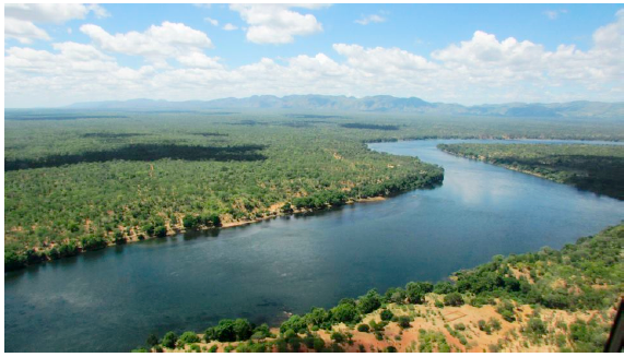
A meandering river
Drainage patterns are easier to identify on vertical aerial photographs. The colour tone of areas covering deep water appears darker than those of shallow water. The various functions of the river can also be identified.
Vegetation
Photographs show all types of vegetation in the photographed area. Planted (artificial) and natural forests appear to be distributed unevenly, with planted forests usually in clear straight lines. In planted forests trees tend to be of the same type, size and height because they were planted at the same time.
The plant characteristics that may appear on the photograph can be used as a guide to the general types of vegetation, for example savannah or semi-arid vegetation. The following guidelines should be used when describing vegetation on a given photograph:
Identify the types of vegetation, for example, forests, thickets, grasslands and swamp plants. Describe the plants, giving details such as height, shape and appearance of leaves. Where possible, give the names of species of plants, e.g. jacaranda, cacti, eucalyptus trees, etc. Planted vegetation should be distinguished from the natural ones by their characteristics. Proper interpretation of vegetation calls upon application of geographical knowledge outside the photograph as well.
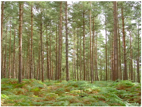
A planted forest
Soil
A clue on the type of soil in a photographed area may be given by the types of crops grown and appearing on the photograph. Rice, for example, grows well in clay soil. Tea and coffee require volcanic soil. Coconuts and cashew nuts thrive well in coastal regions with sandy soils, and a variety of horticultural crops thrive in loam soils.
Proper interpretation of the soil requires an application of one’s general knowledge of geography learnt in classroom as well as knowledge from other disciplines.
Climate
Weather and climate are not shown directly on photographs. Features contained in a photograph can be used to make conclusions about the climate of a photographed area. The type of crops grown and vegetation on the photograph can be used as a clue to establish the climate of a place. Vegetation types and crops can also provide evidence about the season or climate of a place. For example, the presence of many cacti signifies an arid or semi-arid region, and hence a desert or semi-desert climate.
Crops such as sisal are grown in hot areas that receive low rainfall while sugarcane thrives in warm to hot climate with high rainfall. The type of clothing people in the photograph are wearing can give an indication about the weather and possible climate.
Interpreting Features Presented on the Photograph
Interpret features presented on the photograph
Human activities on a photograph are depicted by various forms of land use. The uses of land may in form of agriculture (crop cultivation and animal husbandry), forestry, settlement, wildlife conservation, mining and construction of infrastructures, among other uses.
Agriculture
This includes crop cultivation and livestock rearing. It is practised at subsistence and commercial levels. It is easy to identify agricultural activities on ground photographs. To be able to identify these features on vertical aerial photographs, it requires close examination of the features.
Some evidences that can be used to establish the kind of agricultural activities taking place in an area shown on the photograph are summarized in the table below:
| Type of farming | Evidences to look for |
| Subsistence crop farming |
|
| Subsistence livestock farming |
|
| Commercial livestock farming |
|
| Commercial crop farming |
|
| Plantation farming |
|
Not all the listed evidences in the table for a single type of farming will be available on a single photograph. However, information available may suffice to draw conclusions about the type of farming.
Apart from the types of farming, there are other aspects to be considered when describing and interpreting photographs. These include:
- farming characteristics and the areas where such a type of farming is practised;
- the advantages and limitations of the type of farming;
- the effects of each type of farming to the environment; and
- the government policy on each type of farming.
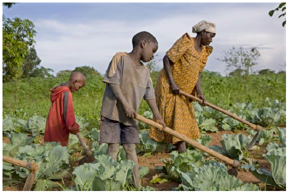
Subsistence farming
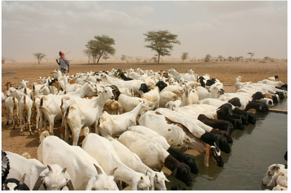
Livestock husbandry
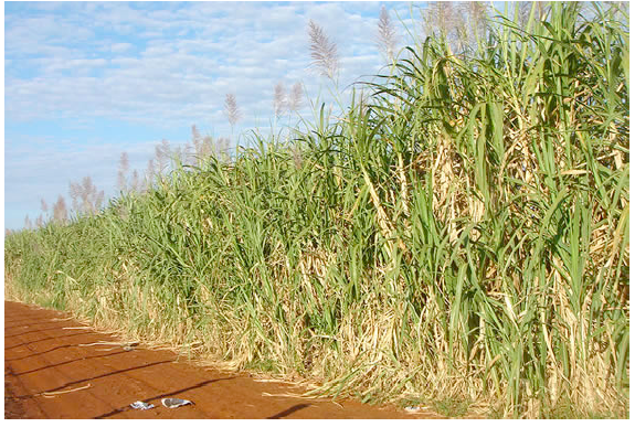
Sugarcane plantation
Settlement
A settlement comprises of a group of buildings in an area where people live and carry out social and economic activities. However, some settlements are made up of institutional, industrial and commercial buildings most of which may not comprise of living houses. Settlements may be of two types, namely, rural and urban settlements.
In photographs, rural settlements can be indicated by the following features:
- Many semi-permanent and a few permanent buildings such as grass-thatched houses or iron-roofed houses with mud or brick walls
- Evidence of farming, cattle herding or fishing activities
- Unplanned or unevenly distributed dwellings or presence of villages Planned settlements in rural areas are associated with institutions or plantations.
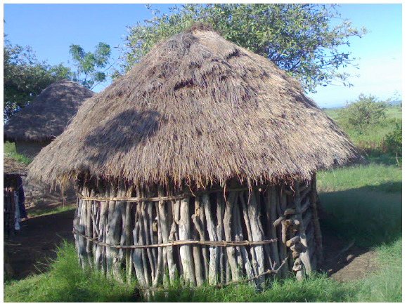
Rural settlement
Urban settlements can be identified by the following features:
- Permanent buildings, which dominate the area
- Regular street patterns
- Buildings with several storeys
- Many large buildings and warehouses indicating an industrial area
- High numbers of people (if they are shown on the photograph)
- Many motor vehicles on the road, which may lead to traffic jams
- Port facilities such as docks, cranes, warehouses and containers
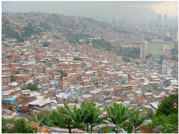
Urban settlement
Not all the listed evidence above will be found on a single photograph. However, there should be sufficient evidence to lead one to make a distinction as to the type of settlement. Settlement patterns can be easily recognized especially from the ground oblique and aerial photographs.
Industrial and mining activities
Various features signalling the presence of industrial and mining activities may also appear on a photograph. It is important that one is familiar with a wide variety of photographs on which these features are shown.
The following evidence can be used as a guide in identifying industrial and mining activities on a photograph:
- Factory buildings with tall chimneys that might be issuing a lot of smoke into the air
- Nucleated settlements in the neighbourhood, likely to be the labourers’ houses
- Tall chimneys emitting flames and a network of pipes with large tanks in the distance could indicate an oil refinery
- Large warehouses close to a building that looks like a factory
- Large open pits, large excavators and lorries carrying loads of rocks could indicate open cast mining
- A large area with derricks (oil rigs) could point to an oilfield where oil is mined
Lumbering
Lumbering activities could be indicated by the presence of the following features/activities:
- People cutting trees using manual or power saws
- People loading timber onto lorries or tractor trailers
- Logs floating down the river
- Logs piled near a saw mill
- Large forest clearings with tree stumps and piles of logs
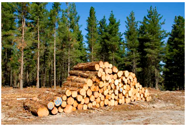
A pile of logs
Transport and communication
Various forms of transport and communication appear differently on photographs. Modes and means of transport can also be identified on a photograph. The following are some of the clues on transport:
- Motor vehicles and roads
- A railway line with or without a train; or just the presence of a named railway station
- A large tamaracked or murram road with buildings on one side, a control tower. Aeroplanes may be seen, or just the presence of a named or symbolized airport may be indicated on a photograph.
- Presence of ports, boats, ships or large water bodies
- Animals carrying loads on their backs
Facilities for communication may be indicated by the presence of telephone lines, telephone booths, satellite dishes, buildings with masts and wires connecting the masts, post office, radio or television station, newspapers or newspaper stands, etc. Other human activities represented on photographs can also have relevant clues that enable one to identify the presence of given communication facilities.
- READ TOPIC 7: Application Of Statistics


No comments:
Post a Comment